
1860 photo taken 4 days after Mr.
Lincoln visited Lincoln, Illinois, for the last time. Info at 3 below.
This President
grew;
His town does too.
Link to Lincoln:
Lincoln & Logan County Development Partnership
Abraham Lincoln Bicentennial Commission of Lincoln, IL

| Internet Explorer is the only browser that shows this page the way it was designed.
Your computer's settings may alter the display.
April 24, 2004: Awarded "Best Web Site of the Year" by the Illinois State Historical
Society
|
|
|

|
Marquee Lights of the Lincoln Theater, est. 1923, Lincoln, Illinois |
|
|
|
6. Introduction to |
|
"The
small towns in central Illinois nearly all owe their existence to the coming
of the railroads in the decade before the Civil War. I have always had
the impression that Lincoln is in some way different from the others but
perhaps that is only because I lived there." ____________________ This page outlines transportation history that connects railroad development to hard road construction in central Illinois. Specifically, the location of Route 66 throughout Illinois was determined by the alignment of the Chicago and Alton Railroad (sometimes called the St. Louis, Alton, and Chicago Railroad). This railroad linked Chicago and St. Louis to Kansas and Nebraska, was responsible for the founding of Lincoln, Illinois, and contributed heavily to the growth and development of central Illinois. (See more about the Alton and Chicago Railroad at 7. The Railroads and Streetcar Line at Lincoln, Illinois, including photos of the celebrated GM&O train named the Abraham Lincoln.) The Significance of Route 66 Route 66 was created in 1926 by the Federal government as a way to connect rural and urban America (California Historic Route 66 Association Web site, "Route 66 -- Historical Background"). In Illinois, Route 66 connected Chicago and St. Louis, paralleling the Chicago and Alton tracks. Lincoln lies on old Route 66 (now I-55) about mid way between these two cities and about mid way between Bloomington to the north and Springfield, the state capital, to the south. Route 66 was formed from the Logan County and state roads that paralleled this railroad. Route 66 has played a vital role in 20th-Century American history. The 1980 census proved that population centers had shifted to Western cities away from the industrialized Northeast and the agricultural Midwest (California Historic Route 66 Association Web site, Route 66 -- Historical Background). US Route 66 is arguably the most significant highway that enabled this massive population shift. Route 66 was all of the following: · "America's first continuously paved link between Los Angeles and Chicago" · "The shortest all-weather route between these cities" · A commercial lifeline for countless rural, small-town, and urban Americans · "The symbolic river of America moving west in the auto age of the 20th Century" · "A symbol of the renewed spirit of optimism that pervaded the country after the economic catastrophe [Depression] and global war [WW II]" (California Historic Route 66 Association Web site, Route 66--Historical Background). In view of this significance, there is little wonder that in the last few years, many Americans who used to travel Route 66 for whatever reasons have expressed nostalgic interest in its history. Route 66 has become a cultural icon, producing countless popular and scholarly publications. One result of this activity is that Route 66 fans search for and travel its remaining pavement. Any place along the "Mother Road" attracts Route 66 fans and stands to gain from this renewed fascination. For many Americans, this renewed interest creates a better understanding of our history and culture. Also, heritage tourism produces substantial economic benefits. A central purpose of this Web site is to inform viewers about the remarkable presence of Route 66 in Lincoln, Illinois, and of some of the Mother Road's remnants there. Maps At the bottom of this page is a map showing the
streets through Lincoln that were used by Route 66 and its predecessor,
Route 4. The navigation bar in the left margin contains links to
several maps showing Route 66 at Lincoln, Illinois. These maps are
designed to help you explore and enjoy this historic part of central
Illinois. |
|
|
The Story of How Route 66 Began in Illinois The 1857 map at the right shows various towns and cities along the Chicago and Alton Railroad. Towns named Atlanta and Elkhart are in Logan County. Lincoln was established in Logan County as a location to provide water to trains on the new railroad. Lincoln's location on the railroad prompted citizens to move the seat of Logan County from Mt. Pulaski to Lincoln. (The map also shows the alignment of the Illinois Central Railroad, which ran from Cairo to Galena and which later branched through Lincoln.) In 1852-1853, the town of Lincoln was laid out with streets parallel with and perpendicular to the Chicago and Alton tracks. This layout deviated from the north-south orientation of streets of the older town of Postville. As streets of one town were aligned with streets of the other town, some "dog leg" connections and small, triangular- shaped blocks resulted. A main road in Logan County,
originally the Springfield Stage Road between Springfield and Ottawa, ran parallel to the
railroad. This road became State Route 4 in 1918, and Route 4 was the
predecessor of Route 66, commissioned by Congress in 1926. Figure 6.1
shows the railroad alignment that was paralleled by the main
northeast-southwest road in Logan County, as seen in 6.3.
The need for hard roads in Illinois became apparent with the growing
popularity of cars in the 1910s: "automobile registrations had
mushroomed from 131,000 in 1914 to over 375,000 in 1918, with the number
swelling daily" (Wrone, 1965, p. 68 ). |
|
|
"With rare exceptions, the roads of Illinois in 1910 differed only in number of miles from the roads of 1818. They billowed clouds of dust in the summer, froze into ruts during the winter, and for two months each spring and fall became quagmires to trap the stoutest horse and the most powerful automobile" (p. 54). City streets, too, were often muddy (p. 55). Photos 6.4 and 6.5 reflect the simultaneous
occurrence of horse-and-buggy and automobile transportation in the 1910s.
Note that the photo of the classy Hudsons was actually taken
two years before the photo of the horse and buggy. The fashionable
drivers of the Hudsons in 6.5 faced the same conditions that mired the horse
and buggy in mud. Figure 6.10 (near the bottom of this page)
shows that Broadway Street in downtown Lincoln was paved in 1916.
Undoubtedly, paved streets in cities increased motorists' desire for hard
roads between cities. |
|
|
6.3: Panoramic View South from Broadwell: Double Railroad Tracks Adjacent to the Highway (Photo from Paul E. Gleason and Paul J. Beaver, Logan County Pictorial History, p. 53) The caption says, "An aerial view of Broadwell's two most important transportation routes. Looking south towards Elkhart one sees the railroad and later Route 4 which eventually became 'Route 66." Today I-55 passes it [Broadwell]," p. 53.
Note: The highway is paved, and so
must date to the 1920s. The rise in the horizon at the left signifies
Elkhart Hill. |
|
|
In his autobiographical short story, "The Man in the Moon," William Maxwell describes the challenges of vehicle transportation in and around Lincoln in the 1910s before hard roads. Maxwell's Uncle Ted Blinn had "persuaded my grandfather to buy a motor car. The distance from my grandfather's house to his law office was less than a mile, and the roads around Lincoln were unpaved, with deep ruts. Even four or five years later, when motorcars were beginning to be more common, an automobile could sink and sink into a mudhole until it was resting on its rear axle. But anyway, there it was, a Rambler, with leather straps holding the top down, brass carriage lamps, and the emergency brake, the gear shift, and the horn all on the outside above the right-hand running board" (p. 254). |
|
|
In her 1979 autobiographical sketch, my maternal Grandmother Blanch Hoblit Wilson mentions the condition of Fifth Street in Lincoln before it was paved. She and her husband, Harrison, had built a grocery store at the corner of Fifth and Washington Streets and operated it throughout the Route 66 era: "Until 1922 Fifth Street from State and Fifth Street Road had dust three and four inches deep in summer. That fall the hard road work began." The construction of hard roads in Illinois became a slow, difficult process
of translating progressive thought into public sentiment and effective
governmental action (one governor slowed hard road development; another
promoted it). In 1912 civic leaders and such private groups as the Chicago
Motor Club sponsored the creation of the Illinois Highway Improvement
Association (IHIA). |
(Wrone, p. 64) |
|
Through the 1920s and
1930s, this Association played a key role in educating the public and
supporting legislation for hard road construction. Effective
communication was needed to overcome the preoccupation of citizens with
World War I and the concerns of farmers, who were often resistant to
governmental programs calling for new public revenues. Figure 6.7
shows the cover of an eight-page pamphlet, one of "six million maps,
posters, folders, and pamphlets" used by the Illinois Highway Improvement
Association to promote the 1918 road-improvement bill (Wrone, p. 71). |
|
|
The Illinois State Bond Issue (SBI) of 1918 was a positive response to Federal legislation of 1916 that provided matching funds for states to construct hard roads. The passage of the 1918 SBI led to the formation of Route 4, but this road was not immediately paved. In the early 1920s, public demand for hard roads grew as "from 1918 to 1925, the total of motor vehicle licenses increased by over 850,000" (Wrone, p. 73). After Route 66 was commissioned in
1926, other conditions favored new road
construction: cement prices and laborers' wages fell . In Illinois, despite
conservatives' objections, another state bond issue was passed in 1924.
More additional money would be needed (to come from a state gasoline tax),
and the Depression complicated construction. |
6.5: Hudson Day, 1916,
at the Country Club of Lincoln, Illinois |
|
Yet, "by the end of 1930, Illinois could boast the finest system of permanent roads in America. From its northern border to Cairo, between the Wabash and the Mississippi, 76 percent of the 10,098 miles comprising the basic highway system was surfaced with concrete" (Wrone, p. 76). Illinois was also the first state to complete paving of Route 66. 6.6: 1920s "Hard Road" Construction in Illinois (Photo from Illinois Magazine, vol. 18, no. 3, April, 1979, p. 4. Unidentified location.)
Note the vehicle at the left is an early dump truck. The large machine
appears to be a combination of concrete mixer and spreader/layer. The
road appears to be one lane: the characteristic early width of nine feet. I count at least 15 men. How
many are working and how many watching?) |
|
|
Significance of Route 66 to Lincoln, Illinois From the 1920s, Route 66 was the main corridor of car and truck transportation linking the Midwest, Southwest, and West. Route 66 brought economic growth and development to towns large and small along its route. Lincoln, Illinois, is a good example. On Business 66 in Lincoln, gas stations, neighborhood grocery stores, and other small businesses flourished. New businesses were established on the edge of town when the "beltline" encircled three sides of it in the early 1940s. At the intersection of Routes 66, 121, and 10, the "Four Corners" developed with numerous gas stations, motels, and restaurants, including the world-famous Tropics and Blu-Inn. This Web site includes other pages with maps, descriptions, and photos of many of the sites along Route 66 in Lincoln from 1926 through the 1960s. |
6.7: Pamphlet in the Hard Road Campaign of 1918. Note the name of William Edens, as in Edens Expressway in Chicago (Wrone, p. 7) |
|
Besides
guiding the alignment of early hard roads, the railroads were also sometimes
used by early pilots to help them navigate. In "Come Fly with Me!" Nancy Lawrence Gehlbach tells the story of how a member of the Wright brothers' "flying
exhibition team" followed the tracks of the Illinois Central Railroad
during a race with a train from Chicago to Springfield. "At Mt.
Pulaski, folks had gathered near the railroad tracks to see the first
airplane to pass over Logan County. . . . The flight established
the first airline route in Illinois" (Our Times, p. 2.). |
|
|
Major Streets and Their Relationship to the Alton & Chicago Alignment in Lincoln
6.8: Panoramic View of Lincoln, Illinois, in 1869 This map shows the different orientation of streets in Postville and Lincoln. Postville street alignments are at the left of the blue line (Union Street), Lincoln's at the right of it. Colors have been added as follows: Green = Alton & Chicago railroad track alignment.
Red on the map corresponds to red on other maps in this Web site to indicate
the streets used by Route 66: Red = Fifth Street (left of Union) and Logan Street
(right);
Blue = Union Street (the street "unifying" Postville and Lincoln);
Maroon = Wyatt Avenue. |
|
|
|
|


|
6.9: Railroad
Alignments, Business
Route 4 (1918-1926), and The green lines of this map show streets used by both Routes 4 and 66. Route 4 streets are in blue, Route 66 in red. Information for the streets used by Route 4 comes from Mr. Larry Shroyer's description in the History of Logan County in Illinois 1982 by Paul Beaver: "Old Route 4 ran from Kickapoo to Broadway west to Sangamon then left on Sangamon to Third Street; it turned on Maple to 2nd Street; down 2nd to College Street -- along First Street to Washington Street and Stringer Avenue. It was completed by 1927" (p. 14). Information for the streets of Business Route 66 comes from my own recollection. Business Route 66 entered Lincoln from the northeast (direction of Bloomington) on Kickapoo, turned northwest on Keokuk, then southwest on Logan Street, which ran adjacent to the downtown business area and present Logan County Courthouse Square Historic District. From Logan Street, Business 66 ran west on Fifth Street, passed the Postville Courthouse block, and turned south on Washington-Stringer Avenue, passing along Postville Park. Business 66 then ran down Cemetery Hill and over Salt Creek toward Broadwell (site of the Pig-Hip Restaurant), Elkhart, and Springfield. |
|
|
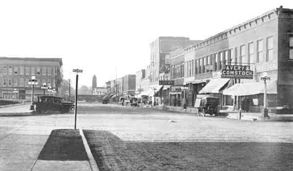
6.10: Broadway
Street Looking West on the Broadway Street looking west from the McLean Street intersection in 1916 (Fish, Illustrated Lincoln). Broadway appears to have a brick pavement. Fish's book does not indicate to what extent streets in Lincoln were paved. William Maxwell recalls from his childhood in the 1910s that "the streets were paved and lighted except on the outskirts of town" (Ancestors, p. 188). I suspect the paved streets were mainly in the business district and the better neighborhoods. Darold Henson, my father, was born in the same year that Route 4 (predecessor of Route 66) was designated (1918). He was born on and raised on Fifth St., becoming part of Business Route 66 in 1926, and he recalls it being paved with bricks sometime during his childhood in the early 1920s. Motorized vehicles are in the foreground. The full-size version of this reduced photo shows a horse-drawn wagon parked down the street on the right. A bicycle leans against the Avery & Comstock storefront. A train is clearly visible in the background, between Chicago and Sangamon Streets. Sangamon Street was the first street behind the train (north of it) and parallel with it. Sangamon Street would also become part of Business Route 4 in 1918. The old Methodist Church building, which stood in the 1950s as the Masonic Temple and attracted pigeons but is now demolished, is visible in the background. It was located at the intersection of Broadway and Logan Street, which would become part of Business Route 66 in 1926. Note on the left in front of the Courthouse
are four, elegant, five-globed electric street lamps. The U.S. post
office is on the corner to the immediate left, city hall on the corner to
the immediate right. |
|
GM&O & Other Railroads in Logan County at the End of the Route 66 Era, 1962
6.11: 1962 Logan County Railroad Alignments, with Route 66 Being Parallel to the GM&O (From Official Plat Book and Farmers' Directory of Logan County, Illinois, 1962, p. 5) This map is labeled "Drainage Map," but the creeks, although shown, are not identified; yet, the various railroad lines are labeled. So, Lincolnites at Heart, can you identify all of the streams of Logan County? |
|
6.12: Illinois, Where
the Mother Road Began; |


|
Sources Cited An American Time Capsule. 1857 Map of the St. Louis, Alton, & Chicago Railroad. http://memory.loc.gov/ammem/amhome.html Gleason, Paul E., and Paul J. Gleason. Logan County Pictorial History. St. Louis: G. Bradley Publishing Company, 2000. Material from Mr. Gleason's books is copyrighted with all rights reserved. Mr. Gleason's material used in this Web site is with permission from the G. Bradley Publishing Company, 461 Des Peres Road, St. Louis, MO 63131. Lincoln: A Pictorial History (1998) (200 pages of rare photos and text) and Logan County Pictorial History (2000) (also 200 pages of rare photos and text). Visit http://gbradleypublishing.com/. California Historic Route 66 Association Web site. http://www.wemweb.com/66_study/toc_0.html The information presented on the page titled "Route 66-Historical Background" is reliable because it is reprinted from Special Resource Study, Route 66 published by the United States Department of the Interior, National Park Service. Fish, Henry R. Illustrated Lincoln. Lincoln, IL: H.R. Fish, 1916. Gehlbach, Nancy Lawrence. "Come Fly with Me!" Our Times, vol. 5, no. 1, spring, 1998. Illinois Magazine. vol. 18, no. 3, April, 1979. Logan County Map of 1895: http://www.livgenmi.com/loganIL.htm Maxwell, William. Ancestors: A Family History, NY: Vintage Books, 1971. William Maxwell's works are available at www.amazon.com and www.barnesandnoble.com. ___________ . "The Man in the Moon" in All the Days and Nights: The Collected Stories. NY: Vintage Books, 1995. Official Plat Book and Farmers' Directory of Logan County, Illinois, 1962. Mankato, MN: No publisher, 1962. Shroyer, Larry. "Old Route 4." History of
Logan County, 1982. The Logan County Heritage Foundation. Dallas, TX: Taylor Publishing
Company, 1982. |
|
Feel free to offer comments, corrections, questions, or
suggestions:
D. Leigh Henson |
|
"The Past Is But the Prelude" |
|
|
|
|
